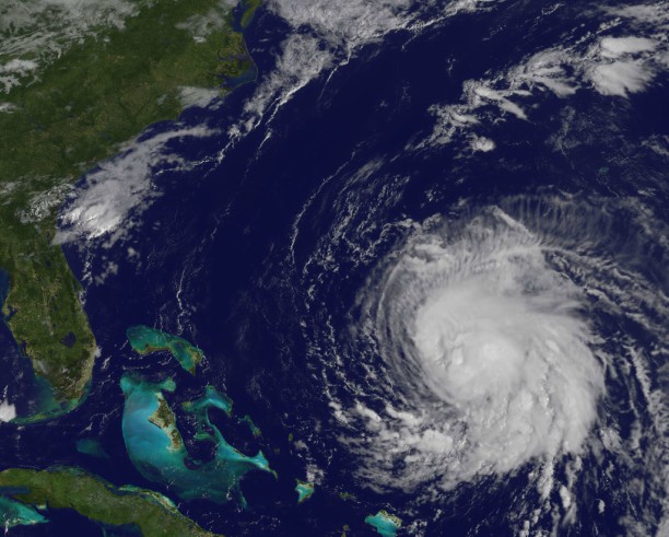
While the East Coast is not a direct target of Hurricane Jose, the region will still be affected as the storm is currently on the move north.
As of 11 a.m., Monday, Jose was centered between Cape Hatteras, North Carolina, and Bermuda, National Weather Service Meterologist Ross Dickman told Metro.
“Over the next 24 to 36 hours, it is expected to move to the northeast, kind of parallel to the coastline, then off to the east and stall out over the weekend, well east of Cape Cod and Long Island,” he added.
Since the storm isn’t expected to directly pass over New York City, Dickman anticipates a “fairly minor” impact on its metro region.
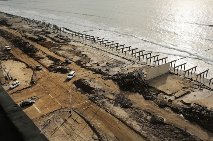
“The only caveat would be the coastal flood impacts,” he said. “We are expecting some minor, possibly some moderate coastal flooding in some of the more vulnerable shoreline locations, like Jamaica Bay or back bay areas. It shouldn’t have too much of an impact in Manhattan, but Staten Island and Bergen Point, New Jersey, could see higher water levels they wouldn’t normally see.”
While that is a concern, “it’s nothing we haven’t seen in the past with, say, a typical nor’easter,” Dickman added.
Jose will not only bring strong winds and heavy rain through Wednesday, the NWS warns, it’s also causing dangerous rip and surf currents along the coast. Tropical storm watches and warnings have been in effect from Fenwick Island and Delaware Bay South in Delaware through Block Island in Rhode Island since at least 8 a.m. Monday.
New Yorkers can anticipate breezy temperatures in the mid- to low-70s and showers through Wednesday evening.
Eastern Long Island, southeast Connecticut, southern Rhode Island and southeast Massachusetts, including Nantucket and Martha’s Vineyard, may see rain accumulations between 3 to 5 inches through Wednesday. The mid-Atlantic coastal region from southeast New York to Maine may also see 1 to 3 inches of rain and isolated flooding, the NWS said.
Boston will be mostly cloudy through Monday evening, when showers and patchy fog arrive and are expected to remain through tomorrow night. Tropical storm conditions are possible come Wednesday, which could lead to strong winds, beach erosion, power outages and flash flooding.
“The system is weakening,” Dickman said of Hurricane Jose, and “as it gets up into our latitude, it should weaken to a tropical storm. We’ll be far enough away from it that the more direct impacts will be felt across extreme southeast New England and not over the New York area.”
On the heels of Jose is Hurricane Maria, which is “rapidly strengthening” in the Caribbean, Dickman said. Initial reports indicated she is strengthening Jose as he travels north, but “they’re not interconnected,” he clarified. “The long-range guidance does suggest there may be interaction between the two cyclones, but now there’s no correlation.”
Though Maria isn’t expected to make landfall until Monday night in the Leeward Islands, the storm’s heavy winds leapt from 90 mph to 120 mph in just three hours on Monday morning. Maria is anticpated to strike Ponce, Puerto Rico, around 8 a.m. Wednesday and the Dominican Republic 24 hours later, Dickman said.
The region is still recovering from the devastation brought by Hurricane Irma less than two weeks ago.
“That area could be in line for some substantial damage because (Maria) is classified as a Category 4 hurricane as it crosses the area,” Dickman said. “This is a particularly dangerous situation for Puerto Rico. We’re expecting six to nine feet of water, perhaps above ground level in terms of storm surge in the southeast part of the island. That can be absolutely devastating for those areas.”