5:30 p.m.
Forecasters said Irene has slightly weakened over the last few hours as it heads up the East Coast toward New England, but that’s not stopping city officials from preparing for the worst.
Mayor Thomas Menino’s office issued a news release less than an hour ago that said Boston’s Emergency Operations Center has been activated.
“The city is being proactive, and urging residents to do the same,” Menino said.
Menino’s office said construction sites are being secured and equipment to remove debris is being readied.
Cambridge isn’t taking any chances either.
Police issued an advisory today that said two emergency shelters would open as early as Saturday night in the unlikely event evacuations are required. Officials also urged residents to secure any loose furniture as strong winds are expected.
Free garage parking for Cambridge residents will be available Saturday from 8 p.m. through 8 a.m. Monday at 260 Green St., 59 First St., Cambridgeside Galleria, 100 Cambridgeside Place and Harvard garage at 52 Oxford St.
Irene’s winds have weakened over the last 12 hours. At 5 a.m., the storm’s winds were clocked at 110 m.p.h. However, the latest National Weather Service update has the winds at 100 m.p.h.
Meteorologists predict that while most of the storm will hit on Sunday day, its effects will be felt earlier.
“Tropical storm conditions are expected to reach southern New England Saturday night with hurricane conditions expected on Sunday,” according to the 5 p.m. NWS update.
–Michael Naughton
5:10 p.m.
The storm is approaching. The most recent reports on Hurricane Irene have turned a “Hurricane Watch” into a “Hurricane Warning” in Martha’s Vineyard, which cut President Obama’s vacation a little short.
Although it hasn’t even started raining in Boston, here is a lit of some essential websites you can keep checking for updates until you eventually run out of power because of the anticipated storm on Sunday.
The latest state-wide information on Hurricane Irene can be found on Mass.gov
The Massachusetts Emergency Management Agency also has posted Preparedness Tips.
For information on roadways, travel conditions and other MassDOT services:
On Twitter
– Follow MassDOT and the MBTA .
You can also follow the Massachusetts Emergency Management Agency
On the Web –
Check the MassDOT Transportation Blog
and the MBTA Website for updates.
Additional resources
are available on MassDOT’s Traffic and Travel Resources page.
Also check RMV Service Alerts for any storm related branch closings.
–Steve Annear. (Follow him on Twitter @steveannear)
5:00 p.m.
Councilor at Large Ayanna Pressley tweeted earlier today:
“@AyannaPressley: If you witness any price gouging related to #Irene please alert my office 617-635-4217”
Last summer, when a water-pipe burst in Western Mass leaving tons of people without freshwater, Attorney General Martha Coakley’s office said they heard a fair amount of reports of stores upping the price of certain necessities.
“Businesses and individuals cannot and should not take advantage of
this public emergency to unfairly charge consumers far beyond what they
would typically charge for water,” said Coakley in a statement last year.
I’m no scientist, but I’m sure the same rules apply. If you think a store is raising the price of water, batteries and other needed items, notify local officials.
–Steve Annear. (Follow him on Twitter @steveannear)
2:55 p.m.
The city’s “NotifyBoston” system and twitter account has advised students who were planning to move on Sunday to think again. Actually, don’t think—just don’t do it.
“Due to Irene and the dangerous weather forecasts, we advise that students not move into off-campus housing on Sunday.”
On campus housing at schools like Emerson and Boston University were advising those traveling from out of state to reconsider their travel plans Sunday and Monday.
Earlier in the week, Metro reported that thousands of students scheduled to start moving to the the city may be thwarted by the hurricane coming into the state.
Check your local college websites or call to find out if move in dates have been postponed due to the expectation of bad storms, rain, winds and all that great stuff.
–Steve Annear. (Follow him on Twitter @steveannear)
2:30 p.m. While the MBTA will remain the same, running trains an buses with some preventative measures in place, JetBlue and the Massachusetts Bay Commuter Rail are possibly cutting back on services.
According to the MBCR’s website:
“Based on current weather reports, MBCR advises all customers of the potential for service delays, cancellations and/or temporary service suspension on all lines, on Sunday, August 29th and Monday, August 30th.
Accordingly, MBCR advises customers to make frequent checks of service alerts/advisories on www.mbta.com for updated travel information before making travel plans on Sunday and continuing through Monday.
While it is too early to predict the severity of the storm’s effect in our area, the extent of potential service disruption is tied to the path of Hurricane Irene. Potential problems include the falling of trees and/or other debris onto the tracks; flooding of tracks; and damage to equipment and track systems.”
The Boston Business Journal reported today that airlines at Logan International Airport began overhauling schedules Friday because of the expected hurricane.
A spokesperson at Logan said re-scheduling will affect close to 80,000 passengers who would travel in or out of the airport on a typical August weekend day.
JetBlue, the biggest airline serving Logan in terms of passenger volume, planned to cancel all flights out of New York Sunday and to close Boston operations Sunday afternoon, a spokeswoman said, according to the Boston Business Journal.
–Steve Annear. (Follow him on Twitter @steveannear)
2:00 p.m.
Following Governor Deval Patrick’s declaration of a State of Emergency for Massachusetts, the State Police issued a release with some steps they want residents to follow as we wait for Hurricane Irene to come barreling toward us in the next two days.
-Residents should be indoors in a secured location by late Saturday evening. While the storm is not expected to begin in earnest until Sunday morning, with the most intense hours expected Sunday afternoon, the possibility exists that its pace could accelerate.
-Residents are urged to stay off the roads Sunday. Heavy rains and heavy winds, with the probability of hurricane-force gusts and the possibility of sustained hurricane-force winds, are expected. The wind and rain will make driving hazardous.
-Any visitors leaving Massachusetts by car are urged to do so as soon as possible, and if at all possible not wait until Saturday night to do so.
-Anyone coming across downed wires or utility poles should, of course, avoid contact with them.
-Anyone having to drive during the storm (which we strongly recommend against) should avoid driving through deep or standing water. Do not drive through water that is higher than the bottom of the wheel rims.
-Residents should have several days of supplies of potable water and non-perishable food in case of prolonged power outages, which are a possibility.
-Residents should have a flashlight, battery-powered radio and extra batteries.
-Please check on elderly or shut-in neighbors if possible.
-Anyone in trouble may call 911 on a cell phone to immediately be connected to a State Police dispatch center.
–Steve Annear. (Follow him on Twitter @steveannear)
1:50 p.m.
So what does a state of emergency mean for people who use the MBTA? Well, right now, nothing.
While New York is planning to shut down its subway systems, Boston is still going to ship people around the city via bus and train, despite the Governor’s call to stay indoors on Sunday.
According to outgoing MassDOT Secretary Jeffrey Mullan, the T will not suspend services.
“We do not expect a disruption in service or service outages at this time,” he said.
Here is a list of initiatives the MBTA is taking in preparation for the storm.
The MBTA is participating in twice a day conference calls with the National Weather Service and the Mass. Emergency Management Agency
– T personnel have been inspecting pump rooms and poor drainage areas all week
– T personnel have performed a survey of dam equipment and the pumps at Fenway tunnel portal
– The MBTA is coordinating with Charles River/DCR personnel up to and during the storm
– The T has retained a professional tree-cutting service for before and during the storm
– The T is developing appropriate staffing plans for weekend
– Observation trains with chain saw-equipped crews will run on all lines Sat. night and into Sunday
– Wire crews and equipment will be deployed on the Blue and Green Lines beginning Saturday night
–Steve Annear. (Follow him on Twitter @steveannear)
1:40 p.m.
Patrick urged residents to stay indoors, all through Saturday night and all day Sunday and to stay off of the roads so that emergency crews can tend to fallen trees and other hazardous situations.
“As we prepare for the storm I want to tell the public to make measures so they are prepared. Make sure you have supplies on hand. if you need medications make sure they last the next couple of days,” said Patrick during a press conference today.
Patrick called on Massachusetts residents to check on neighbors and make sure they are OK and secure and stay indoors and off the roads from tomorrow evening through the end of the storm.
“We are expecting the beginning s of the storm tomorrow afternoon but the heaviest rains during the day combined with rain and wind through Sunday,” he said. “It’s better for everyone if your’e indoors so emergency responders can do their job.
Patrick said people should exercise extreme caution because they expect downed power lines and trees.
Rip tides and strong currents are expected and will be a serious hazard to swimmers and boaters, he said.
Patrick said people should not travel this weekend, and do any traveling today.
The state anticipates that the hurricane will go right through the path of the tornado from June, hitting Springfield, which is already damaged after the last storm several months ago.
What is a state of emergency?
state law to declare a Gubernatorial State of Emergency upon the
occurrence of a natural or man-made disaster.The law gives the
Governor broad authorities to implement emergency measures to ensure the
safety and health of the residents of the Commonwealth, take
appropriate steps to mobilize state assets, and conduct other emergency
business for the protection of the Commonwealth.
–Steve Annear. (Follow him on Twitter @steveannear)
12:45 p.m.
Even President Obama is worried about the storm. He said anyone in its path should take it seriously and “hope for the best, but prepare for the worst.”
MEMA updated some information on its website, including what sort of damage can occur inland, aware from the shores.
“Hurricanes or tropical cyclones are not merely coastal events or wind
events. Due to the fact that Massachusetts is a relatively small state,
depending upon the storm’s track, the entire Commonwealth could be
severely impacted by a tropical storm or hurricane. The destruction
dealt by the devastating winds can result in destroyed buildings, downed
trees and power outages. However, the greatest damage is usually due to
the impact of flooding.”
–Steve Annear. (Follow him on Twitter @steveannear)
12:20 p.m.
Patrick has activated 500 National Guard
soldiers for Massachusetts as we wait patiently for Irene to come hammering through the state with torrential downpours, high winds and some possible destructive activity.
At 1:15 p.m. the governor is scheduled to talk about the state’s other preparations for the
storm, which we are anticipating to feel the effects of on Sunday.
Metro will be at the governor’s afternoon update and will be dishing out the latest news right after. Stay tuned.
–Steve Annear. (Follow him on Twitter @steveannear)
11:00 a.m.
The state’s mass.gov website released tips on how to handle extended power outages. According to a spokesman from the National Weather Service, Boston and surrounding areas could see “power outages for days” and the Massachusetts Emergency Management Agency wants you to be prepared.
MEMA has provided the following tips:
• Check flashlights and portable radios to ensure that they are working, and you have extra batteries on hand.
• If your water supply could be affected by a power outage (a well-water pump system), fill your bathtub and spare containers with water. Water in the bathtub should be used for sanitation purposes only, not as drinking water. Pouring a pail of water from the tub directly into the bowl can flush a toilet.
• Set your refrigerator and freezer to their coldest settings (remember to reset them back to normal once power is restored). During an outage, do not open the refrigerator or freezer door unnecessarily. Food can stay cold in a full refrigerator for up to 24 hours, and in a well-packed freezer for 48 hours (24 hours if it is half-packed).
•If you have medication that requires refrigeration, check with your pharmacist for guidance on proper storage during an extended outage.
• Follow the manufacturer’s instructions and guidelines when using a generator. Always use outdoors, away from windows and doors. Carbon Monoxide fumes are odorless and can quickly accumulate indoors. Never try to power your house by plugging the generator directly into household wiring, a practice known as “backfeeding.” This is extremely dangerous and presents an electrocution risk to utility workers and neighbors served by the same utility transformer. It also bypasses some of the built-in household circuit protection devices.
• In order to protect against possible voltage irregularities that can occur when power is restored, you should unplug all sensitive electronic equipment, including TVs, computers, stereo, DVR, VCR, microwave oven, cordless telephone, answering machine and garage door opener. (Review the process for manually operating your electric garage door.)
• Be extra cautious when you go outside to inspect for damage after a storm. Downed or hanging electrical wires can be hidden by trees or debris, and could be live. Never attempt to touch or move downed lines, and keep children and pets away from them. Do not touch anything power lines are touching, such as tree branches or fences. Always assume a downed line is a live line. Call your utility company to report any outage-related problem.
–Steve Annear. (Follow him on Twitter @steveannear)
10:23 a.m.
According to a Tweet from Governor Deval Patrick’s office, a “Flood Watch”has also been issued for all of Massachusetts.
–Steve Annear. (Follow him on Twitter @steveannear)
10:06 a.m.
Some people may be wondering what the difference between the issued
watches are. Well, Metro rounded up the most basic definitions for you.
According to FEMA and the city of Boston’s website, here is what you should know about issued warnings.
Hurricane: Generally, an intense tropical weather system of strong thunderstorms, with maximum sustained winds of 74 mph or higher.
Tropical Storm: Generally, an organized system of strong thunderstorms, with maximum sustained winds of 39-73 mph.
Hurricane/Tropical StormWatch: A hurricane or tropical stormis possible in your area, usually within 36 hours.
Hurricane/Tropical Storm Warning: A hurricane or tropical storm is expected in your area, usually within 24 hours.
–Steve Annear. (Follow him on Twitter @steveannear)
9:28 a.m.
Hurricane Irene is still more than 48 hours away from Massachusetts but the National Weather Service has issued a Hurricane Watch for coastal areas and towns in the Commonwealth and a tropical storm watch for the interior parts of the state.
Six states have already declared a state of emergency, but Massachusetts, and Boston, is still planning efforts and trying to predict what the impact of the hurricane could be.
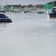
According to a Globe report, a spokesperson from the National Weather Service said flooding is expected along both the state’s east and south coasts, but the south coast is expected to be hit hardest.
“Its been quite sometime since [the state] has experienced a hurricane of this magnitude so we want to make sure people are prepared and avoiding travel,” said a spokesman from the Massachusetts Emergency Management Agency.
Weekend plans should be reconsidered, according to reports. Already, concerts at Gillette Stadium and the Comcast Center have been postponed and both the Red Sox and New England Revolution have abandoned games this Sunday in anticipation of the storm.
The following counties are under a Hurricane Watch:
Barnstable; Dukes; Eastern Essex; Eastern Norfolk; Eastern Plymouth; Nantucket; Southern Bristol; Southern Plymouth; Suffolk
The following counties are under a Tropical Storm Watch:
Central Middlesex County; Eastern Franklin; Eastern Hampden; Eastern Hampshire; Northern Bristol; Northern Worcester; Northwest Middlesex County; Southeast Middlesex; Southern Worcester; Western Essex; Western Franklin; Western Hampden; Western Hampshire; Western Norfolk; Western Plymouth
–Steve Annear. (Follow him on Twitter @steveannear)