Boston weather is set to experience a relative heat wave following last week’s brief-but-brutal brush with the dreaded polar vortex.
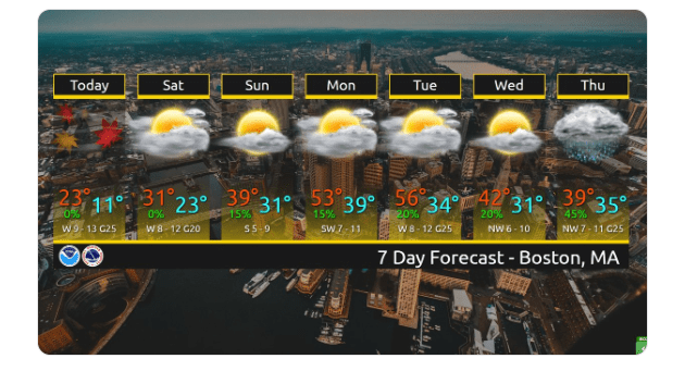
The National Weather Service predicts a cold start to a sunny Monday for the Bay State, but then temperatures are expected to jump up to as high as about 54 degrees.
Monday evening will see a low of 38 degrees with slight chance of rain around 3 a.m..
Tuesday is expected to be a far cry from the frigid polar vortex just a few short days ago, with temperatures reaching a high near 60 degrees.
The rest of the week will cool down, with temperatures returning to the low 40s and mid-30s. While these temperatures aren’t expected to break any records, they are unseasonably pleasant nonetheless.
Forecasters predict a sunny day with a high near 40 degrees on Wednesday, with a more seasonable cold and cloudy weather rolling in for the remainder of the week starting with a 50 percent chance of a rain/sleet mix in the evening hours.
There is a chance of lingering rain showers possible throughout Thursday and Friday, with temperatures dipping into mid-30s on Thursday night. Friday is expected to have a high of 45 degrees before clearing up in the evening.
For the weekend, however, a cold front is expected to head our way, with temperatures expected to drop to about 25 degrees. Northern Central Massachusetts and southern New Hampshire are advised to expect icy conditions.
NWS Boston tweeted: “After another very cold day, temps moderate to seasonable levels this weekend with dry weather continuing. Highs should reach well above normal early next week before colder weather returns by Wednesday. Next real chance for precipitation will be late next week.”
Weather.gov warned that “there is the potential for a period of icing in the form of freezing rain and sleet, mainly across interior southern New England sometime Wednesday night into Friday. This may eventually require the need for winter weather headlines, but a lot of uncertainty remains.”